Text

Uploading as many photos as possible, looking to add full text eventually...

Dec 19, 2021

Atlantic Huron

The ATLANTIC HURON arriving at Iroquois Locks.
The ATLANTIC HURON is instantly recognizable by the square anchor port above the base of the white forcastle...

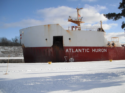
The ATLANTIC HURON was built in 1983 at Collingwood Shipyards.

Other Collingwood vessels with this look have since been retired; ALGOWEST, JOHN B. AIRD, and the PATTERSON (aka PINEGLEN).


ATLANTIC HURON (originally launched as PRARIE HARVEST) was built in 1983 for Canada Steamship Lines.

At a whopping 736.5 feet in length, she and the 1984-built ATLANTIC ERIE (Collingwood Shipyards hull #225 ex HON. PAUL MARTIN) along with the 1985-built PATTERSON (aka PINEGLEN) were among the longest vessels to transit the Seaway for well over a decade...


Canada Steamship Lines rebuilt four of their vessels in 1999-2000, lengthening them to 739 feet and re-launching them with new names:
H.M. GRIFFITH became the RT. HON PAUL MARTIN
JEAN PARISIEN became CSL ASSINIBOINE
LOUIS R. DESMARAIS became CSL LAURENTIEN
J.W. MCGIFFN becomes the CSL NIAGARA.

In 2012, CSL began launching brand new "Trillium Class" self unloaders (made in China), starting with 740 foot fleetmates like BAIE ST. PAUL.


The ATLANTIC HURON (aka. PRARIE HARVEST) was built for easy conversion to a self-unloader.

After being rebuilt in 1989, she returned to service as the ATLANTIC HURON (2).


Confusingly, the ship previously known as ATLANTIC HURON became the CSL INNOVATOR.

The "new" ATLANTIC HURON (2) also sailed as MELVIN H. BAKER II from (1994-1997) before her name of ATLANTIC HURON (2) was restored.


Looks like there's room to spare...

If she's 736 feet long, and the new "SeawayMax" ships are 740 feet - Surely they can cram a 750 foot vessel in there...


As the ATLANTIC HURON transits the Iroquois Locks, the FEDERAL MONTREAL is still moored to the lower wall below the lock.

Either the FEDERAL MONTREAL suffered damage during the intense windstorm last week, has some kind of technical malfunction, or otherwise being held by officials until the issue is resolved.

The big red ocean-going vessel was moving under her own power, only obtaining the assistance of a tug to dock the ship against the side wall.


Another look at the superstructure. Mix of sun and clouds, but fortunately had ideal lighting conditions for some decent shots of this huge ship.


Another look with the FEDERAL MONTREAL off to the side of the locks, while ATLANTIC HURON is in the lock itself.


Got treated to THREE vessels during one trip to the Locks...

Although the FEDERAL MONTREAL was in the same position as she was two days ago, she made an interesting background piece.

A grey-hulled upbound cement carrier (NACC QUEBEC) is visible behind the mast of the ATLANTIC HURON.


The upbound NACC QUEBEC is next to use the lock...


While I'd liked to have sees that interesting little cement-carrying vessel up close, I had to follow the ATLANTIC HURON downriver...


Anticipating that the huge ship will pull a U-turn in the channel to line herself up for her next delivery - But unsure exactly where

Fortunately, someone in the know pointed me to the spot...


Laker Pulls a U-Turn...

The downbound ATLANTIC HURON prepares to execute a rare 180 degree turn to line herself up with the dock upriver to deliver a payload of road salt.

It's amazing how wide the St. Lawrence Seaway channel is in some places, especially near the Wilson Hill anchorage.

The vessel was able to pull a slow, wide turn... Nothing dramatic like the dropping of the anchor chain, careening of the ship as the back end swings wildly around ...


Wasn't sure if there would be time to pull off this maneuver with the upbound vessel PAUL A. DESGAGNES approaching. Even on Highway H2O, someone can decide to pull a U-turn right in front of you. The nerve!


The ATLANTIC HURON, now facing west with her bow pointing upriver. The vessel slowly drifts backwards with the current as the smaller DESGAGNES ship overakes her.

The western-most anchorage buoy XC is visible in the middle of the shot.


An unusual sight on the shipping channel, with three vessels now heading upbound....

With the purple sky and pretty snow, there's no place else I'd rather be than at the River.


Dec 18, 2021

Federal Montreal, Irma, Amy Lyn D

Arrived at the Iroquois Locks, hoping to catch an upbound ship. The ship I'd been tracking (ALGONORTH) was nowhere to be seen...

Instead of a tiny tanker, be the first thing I saw over the hill was the deck cranes of ocean-going vessel FEDERAL MONTREAL...


There were actually two downbound saltwater ships at the lock.

The FEDERAL MONTREAL was inside the lock, while the Polsteam vessel IRMA was tied to the upper wall (west side).


Spending time near the channel but nowhere near a port, it's not every day that I get to see one of these huge freighters just sitting there...


The tugboat AMY LYN D was upbound, awaiting her turn to use the lock.

Much to my surprise, the tug actually helped push the huge cargo ship FEDERAL MONTREAL off to the sidewall and out of the shipping lane.

All in a day's work for the mighty little tugboat.


Always been fascinated by the videos and photos of tugs assisting vessels - But had never actually seen this for myself.

Got to feel like a little kid watching a big red ship go through the locks...


After assisting the freighter, the AMY LYNN D cruised through the locks and upriver towards her next assignment.

Dec 8, 2021

Movie Knight...


JOHN SHERWIN in Chicago
Watching The Dark Knight (one of the best Batman movies), one can spot a docked Great Lakes ship somewhere around 1 hour 42 minutes into the film.


JOHN SHERWIN during her active career.
Although the name of the boat is edited out, apparently the vessel is the long-idle JOHN SHERWIN.

The ship had been briefly towed to Chicago, and appears only during an establishing shot in the movie.

It's possible that the following scene (with the Joker and gangsters) is supposed to be in the ship's cargo hold.


The JOHN SHERWIN has a sistership in active duty... The HON JAMES L. OBERSTAR was converted to a self unloader, and just happened to see a video of her heading out onto the Lakes.

Hon James L Oberstar departed Duluth 11/05/2021
https://www.youtube.com/watch?v=29oU8LU9Axs
Duluth Harbor Cam

Dec 7, 2021

Great Laker...

"Abandoned 806-foot Great Lakes Freighter.
August 2021 - John Sherwin (2)
"
by Casey Buckleitner
https://www.youtube.com/watch?v=nb59vyDHHe8
While I've never actually seen the 806 foot long JOHN SHERWIN (as she's too big for the Seaway), I was familiar with the Interlake Steamship Company thanks to the pages of Know Your Ships.

Anchored and sitting idle near the Great Lakes, it seems unlikely that this ship will ever be powered again.

A guy in a motorboat takes a pass by the abandoned ship, offering a close view of this huge vessel, including a great look at the bowthruster.


Towards the end of the same video, the front of another laker is sitting in the shore... Seems as if someone has turned it into a building.

This one is the JOHN W. BOARDMAN, built in 1925. The hull of the 390 foot vessel was scrapped in 2003, with the forward wheelhouse and bow being moved onto land to become a private cottage.

"In November 2005 the forward section was moved onto a barge and pushed down the St. Mary's River to Detour."
-boatnerd.com

Sleek and shiny with a fresh coat of paint... Glad they decided to keep the ship's name and colors.
Just imagine the wheelhouse as a living space, looking out onto the water...

Natural curiosity over the ship-turned dwelling caused me to discover this article:
"From Lakes Freighters to Lake Houses"
http://www.oldsaltblog.com/2014/08/from-lakes-freighters-to-lake-houses-benson-ford-john-w-boardman/


Nov 29, 2021

The Lost Hamlet of Woodlands?


Woodlands is one of the small, forgotten settlements among the Lost Villages of the St. Lawrence Seaway. 

After more than six decades spent underwater, these Lost Villages have become "The Atlantis of Ontario".

Located just south of modern day Ingleside, the farming community of Woodlands was also a summer tourist destination.

The name carries on today with the Woodlands Campsite.


The original settlement known as "Woodlands" is now submerged, somewhere along the Old Highway #2 (also underwater).

But where exactly is this long lost hamlet?

The maps provide a generally vague direction, and each map shows a slightly different location. The tiny hamlet of Woodlands almost gets forgotten behind the larger nearby Lost Villages of Aultsville and Farran's Point.

While small in population, Woodlands may have stretched further than one might imagine... Farms generally being further apart than residential dwellings, Woodlands could have stretched all the way to just south of modern Farran Park Campground.


A number of shoals exist in this section of river - Directly south of Ingleside, right along the Old Highway #2.

Huge piles of rocks... Or foundations???


In the series of shoal markers from Long Sault to Ingleside, this one bears number 17.

(Southeast of Farran Park Campground, Southwest of McLaren Campground)


Zooming in with Google Maps, the eerie shapes begin to appear...
Stones arranged in shapes that can only be man-made.
Squares and rectangles beneath the waves - Buildings of two farm properties, side by side?


Looking southeast at these rocky shoals from the small unnamed island south of Farran Park Campground.
(the island bears the orange shoal marker number 19)

This tiny island is technically on the same "shelf" as Bredin Island - Is it possible that Woodlands extended this far?


Bredin Island on the left, Croil Island on the right.

Woodlands, under the water somewhere.


Extreme zoom, looking southeast (from the tiny unamed island south of Farran Campground).


Down from the current (looking north from the tiny island south of Farran's Park) is a huge sand bar, with history potentially burried beneath it.

A small square and rectangle have caught my attention on Google Maps.

With a collection of big rocks lined up together, I believe that yet another farmhouse and barn were located just off the southeastern tip of this unnamed island.


I have also heard of a Woodlands church foundation that's above water - although I'm unsure of the location. Someone may have simply confused it with the church foundation on Wales Island.

Apparently there were two churches in Woodlands, at least one of them located by the cemetery along the Old Highway #2.


As for "downtown" Woodlands (presumably further east) - That particular stretch of Old Highway #2 appears to be in remarkably good condition. Following the highway on Google Maps, one can make out tiny foundations that dot the line, pretty much all the way to the next sunken hamlet (Santa Cruz).


On a calmer (and warmer) day, I'd be interested in checking it out to see what else is down there...


Shoals on the St. Lawrence (Marking Long Sault to Ingleside)

Rocks in the middle of the river,
southeast of Long Sault Parkway

A number of shoals exist on the St. Lawrence River, making the waterway particularly challenging to navigate.


Seems as if someone has placed approximately 20 of these orange markers from Long Sault to Ingleside.

Each has an orange triangle with a black stencilled number. The digits begin in the east and progress west.


Huge rock pile, evidence of something man-made...

The first shoal I noticed was southeast of the Long Sault Parkway, approximately one kilometer south of Moulinette Island, Long Sault.

I've dubbed it "Sheek Island Shoal". Old maps seem to indicate that this was once part of Sheek Island.

I now believe this huge pile of rocks to be the remains of the "Sheek Island Dam" that would have been 
located in this area.


I'll have to re-visit the Long Sault Parkway to confirm, but the next marker  may be just off Royal Baker Island where a section of Old Highway 2 emerges as a hazard.


South of Farran Park Campground

Some of these orange markers indicate treacherous rocks that can be hidden below the water...

Other markers appear to be placed on small islands.


Bredin Island

Marker number 15 at Bredin Island, just south of Ingleside.


Marker 17, just north of Old Highway 2

Another exists southwest of the Parkway, near another section of Old Highway 2.

Huge rocks are dangerously close to the 
surface, often emerging when water levels are low. This is marker number 17.

Possible location of farm buildings and dwellings from the lost hamlet of Woodlands?


Standing on the unnamed island south of Farran Park

Directly south of the Farran Campground is an unamed island, that everybody and their dog visits in the summertime 
(literally).

Marker number 19 can be found here.


Looking north towards Farran Park Campground

The wooden markers are still relatively solid, some of them managing to survive for over a decade now.

It's neat to find them as part of this scavenger hunt - But sadly, some of them may not exist anymore...

Ice flowing downriver 
in the springtime is strong enough to move concrete blocks - A wooden sign post can only last so long.

During this leg of the "scavenger hunt", markers 16 and 18 appear to be MIA.


Remains of Farran's Point

The markers conclude somewhere around the ruins of Farran's Point (with marker number 20), west of Farran Park Campground (southwest of Ingleside).


Not sure if these orange signs were part of a documentation or study, but I've always been curious.

It's only in one small section of the 
river, and they don't seem to be "official" (not installed by the government, Hydro or Seaway).


Hazard marker number 20, Farran's Point
Standing on Old Highway 2, looking towards the re-located County Road 2

The sign post of marker number 20 at Farran's Point has been broken.

Seems fellow explorers have propped it back up with rocks.

It may very well float away in the spring of 2022.


Mallard Ducks
Always see ducks on the river in the fall, have noticed even more Mallards this year...


Appears to be three males and one female in this group.


Nov 25, 2021

Thunder in Paradise... (CSL's THUNDER BAY)

Tamarack tree beside the river's edge

Was hoping to be at the river in time to see the Canada Steamship Lines-owned THUNDER BAY make her way upstream.

The view is always great, particularly on this cold but clear autumn day.


Waiting for the ship to arrive, noticed a fairly large group of Mallard Ducks in the bay.

Happened to capture some of them mid-flight.


The bow of THUNDER BAY (3) appeared first as the vessel emerged from behind an island.

At one time, CSL's "Bay Class" was made up of straight-deck bulk carriers.

The modern-day "Bay Class" is comprised of self-unloaders.


The ship will continue upriver, but directly ahead of her is a huge pile of road salt, some of which was delivered by her sister ship BAIE COMEAU.

(The ALGOMA COMPASS and ALGOMA INTREPID have also dropped salt here this year)


This is actually the third "THUNDER BAY" to sail in CSL colors. The very first "THUNDER BAY" was originally a barge from 1890, converted to a steamer when she was acquired by Canada Steamship Lines in 1921.
https://www.maritimehistoryofthegreatlakes.ca/GreatLakes/Documents/Scanner/10/07/default.asp?ID=s008


The second "THUNDER BAY" (1952) also had a forward pilothouse.

This vessel was initially built as a straight-deck bulk carrier.


THUNDER BAY (2) was converted to a self-unloader (in 1967-68) and bore the name STADACONA (3) with a black hull until she was scrapped in 1991.