
Lost Village of Aultsville
A brief summary with some of my favorite images.
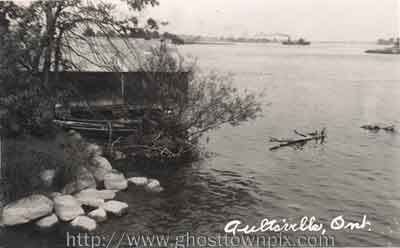 |
| Aultsville Postcard Looking out onto the St. Lawrence River from Aultsville, a steamer heads upstream. A small island is visible in the middle of the river - Possibly the hazard known today as Steen Shoal. |
 |
| Color illustration of "Main Street looking East". |
 | |
| Looking towards the railroad tracks. Unsure as to whether the view is looking north or south... If this is in fact the old Aultsville Road, then this section of train track has become the modern-day bike path known as "Waterfront Trail" | . |
 |
| Looking south, down the old Aultsville Road (aka Nelson Street). The main intersection of Aultsville is in the upper middle, Old Highway #2 stretching east to west. Ault Island is on right. |
 |
| Great aerial shot of (presumably) Old Highway #2 through Aultsville. A few tree stumps are visible, along with many objects casting shadows... Canada Geese? |
 |
| Another neat shot of the Old Highway #2. I believe huge patches of seaweed are growing all around it. |